 vesseltracker.com
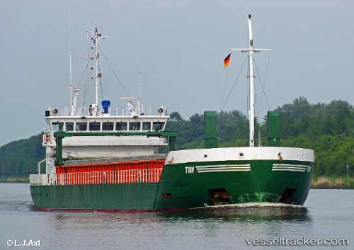
 Tim
Tim
Current Status
Where is the vessel?
Tim is currently in 18 nm SE of Killough, based on AIS data received about 1h ago.
Latest AIS update:
Current position: 53.97696° N, 5.43615° W (18 nm SE of Killough)
Average speed (last 7 days): Loading…
Average speed (last 30 days): Loading…
Vessel profile: Tim is a General Cargo Ship with dimensions 82m x 12m.
This page combines live AIS, route history, probable destination signals, nearby traffic, and port activity for practical vessel monitoring.
The current position of vessel Tim is 53.97696 lat / -5.43615 lng. Updated: 2026-05-16 03:29:57 UTCNearest reference points:
- Near Crossgar
- Near KILKEEL
- Near Skerries
Currently sailing under the flag of Cyprus ![]()
Tim built in 2008 year
Deadweight:
3450 tDetails:
Live Vessel Tim Analytics (details, animations, etc.)
Recent AIS points (UTC):
2026-05-15 23:43:17 UTC · 54.55585, -5.36458 · SOG 8.3 kn · COG 160°2026-05-16 01:54:18 UTC · 54.24067, -5.37440 · SOG 9.4 kn · COG 192°
2026-05-16 02:31:37 UTC · 54.13922, -5.39870 · SOG 9.9 kn · COG 187°
2026-05-16 03:29:57 UTC · 53.97696, -5.43615 · SOG 10.1 kn · COG 188°