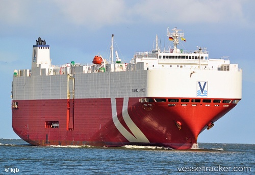
 SEBRING EXPRESS
Current Status
Where is the vessel?
SEBRING EXPRESS is currently in 158 nm W of Cap Skiring, based on AIS data received about 15h ago.
Latest AIS update:
Current position: 12.59920° N, 19.43560° W (158 nm W of Cap Skiring)
Average speed (last 7 days): Loading…
Average speed (last 30 days): Loading…
Vessel profile: SEBRING EXPRESS is a Vehicles Carrier with dimensions 30m x 180m.
This page combines live AIS, route history, probable destination signals, nearby traffic, and port activity for practical vessel monitoring.
The current position of vessel SEBRING EXPRESS is 12.5992 lat / -19.4356 lng. Updated: 2026-05-24 07:40:34 UTCNearest reference points:
- 48 nm W of Cap Skiring
- Near Dakar
- Near Rufisque
Currently sailing under the flag of Malta ![]()
SEBRING EXPRESS built in 2009 year
Deadweight:
15154 tDetails:
Live Vessel SEBRING EXPRESS Analytics (details, animations, etc.)
Recent AIS points (UTC):
2026-05-24 05:12:39 UTC · 13.22880, -19.53840 · SOG 15 kn · COG 171°2026-05-24 05:38:44 UTC · 13.11870, -19.52060 · SOG 15.1 kn · COG 171°
2026-05-24 07:37:09 UTC · 12.61390, -19.43730 · SOG 15.6 kn · COG 173°
2026-05-24 07:40:34 UTC · 12.59920, -19.43560 · SOG 15.6 kn · COG 173°