 vesseltracker.com
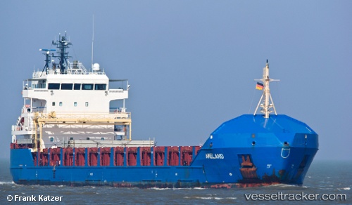
 KAARI
KAARI
Current Status
Where is the vessel?
KAARI is currently in 27 nm SW of Sindhos, based on AIS data received less than 1h ago.
Latest AIS update:
Current position: 40.28667° N, 2.16833° E (27 nm SW of Sindhos)
Average speed (last 7 days): Loading…
Average speed (last 30 days): Loading…
Vessel profile: KAARI is a General Cargo with dimensions 116m x 16m.
This page combines live AIS, route history, probable destination signals, nearby traffic, and port activity for practical vessel monitoring.
The current position of vessel KAARI is 40.28667 lat / 2.16833 lng. Updated: 2026-05-15 19:42:25 UTCNearest reference points:
- Near El Port
- 16 nm SW of Sampedor
- 24 nm SW of Sampedor
Currently sailing under the flag of Antigua Barbuda ![]()
KAARI built in 2009 year
Deadweight:
6390 tDetails:
ex Ameland
Live Vessel KAARI Analytics (details, animations, etc.)
Recent AIS points (UTC):
2026-05-15 16:36:25 UTC · 40.17667, 1.47333 · SOG 10 kn · COG -1°2026-05-15 17:51:23 UTC · 40.22167, 1.75833 · SOG 10 kn · COG -1°
2026-05-15 19:00:24 UTC · 40.26167, 2.02167 · SOG 9 kn · COG -1°
2026-05-15 19:42:25 UTC · 40.28667, 2.16833 · SOG 9 kn · COG -1°