 vesseltracker.com
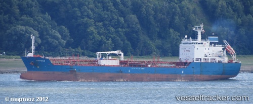
 TROMSO
Current Status
Where is the vessel?
TROMSO is currently in 90 nm SE of Batonbaton, based on AIS data received about 2h ago.
Latest AIS update:
Current position: 7.90667° N, 119.13167° E (90 nm SE of Batonbaton)
Average speed (last 7 days): Loading…
Average speed (last 30 days): Loading…
Vessel profile: TROMSO is a Oil/Chemical Tanker with dimensions m x m.
This page combines live AIS, route history, probable destination signals, nearby traffic, and port activity for practical vessel monitoring.
The current position of vessel TROMSO is 7.90667 lat / 119.13167 lng. Updated: 2026-05-02 13:41:34 UTCNearest reference points:
- 35 nm SE of Brookes Point, Palawan
- 66 nm W of Jolo
- 70 nm W of Puerto Princesa
Currently sailing under the flag of Antigua and Barbuda ![]()
Details:
Live Vessel TROMSO Analytics (details, animations, etc.)
Recent AIS points (UTC):
2026-05-02 10:08:35 UTC · 7.67500, 119.79500 · SOG 11 kn · COG -1°2026-05-02 11:59:33 UTC · 7.79667, 119.44833 · SOG 11 kn · COG -1°
2026-05-02 13:20:34 UTC · 7.88167, 119.19833 · SOG 11 kn · COG -1°
2026-05-02 13:41:34 UTC · 7.90667, 119.13167 · SOG 12 kn · COG -1°