 vesseltracker.com
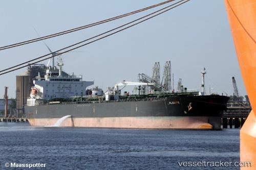
 ALIGOTE
Current Status
Where is the vessel?
ALIGOTE is currently in Near Yanbu Industrial City, based on AIS data received about 3h ago.
Latest AIS update:
Current position: 23.94162° N, 38.20545° E (Near Yanbu Industrial City)
Average speed (last 7 days): Loading…
Average speed (last 30 days): Loading…
Vessel profile: ALIGOTE is a Chemical/Oil Tanker with dimensions 230m x 32m.
This page combines live AIS, route history, probable destination signals, nearby traffic, and port activity for practical vessel monitoring.
The current position of vessel ALIGOTE is 23.94162 lat / 38.20545 lng. Updated: 2026-04-29 20:46:15 UTCNearest reference points:
- 30 nm SW of Yanbu
- 42 nm NW of Fiji
- 35 nm S of Umm Lajj
Currently sailing under the flag of Marshall Islands ![]()
ALIGOTE built in 2010 year
Deadweight:
74192 tDetails:
Live Vessel ALIGOTE Analytics (details, animations, etc.)
Recent AIS points (UTC):
2026-04-29 19:26:11 UTC · 23.94159, 38.20556 · SOG 0.1 kn · COG 291°2026-04-29 19:50:11 UTC · 23.94152, 38.20546 · SOG 0.1 kn · COG 296°
2026-04-29 20:46:15 UTC · 23.94162, 38.20545 · SOG 12.3 kn · COG 292°
2026-04-29 20:46:15 UTC · 23.94162, 38.20545 · SOG 12.3 kn · COG 292°