 vesseltracker.com
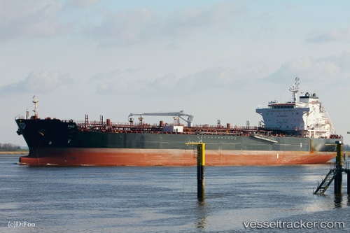
Pag
Current StatusWhere is the vessel?
Pag is currently in Near Zona Franca de Iquique, based on AIS data received less than 1h ago.
Latest AIS update:
Current position: 20.19603° S, 70.14418° W (Near Zona Franca de Iquique)
Average speed (last 7 days): Loading…
Average speed (last 30 days): Loading…
Vessel profile: Pag is a Chemical Oil Products Tanker with dimensions 32m x 183m.
This page combines live AIS, route history, probable destination signals, nearby traffic, and port activity for practical vessel monitoring.
The current position of vessel Pag is -20.19603 lat / -70.14418 lng. Updated: 2026-05-14 14:13:39 UTCNearest reference points:
- Near Arica
Details:
Live Vessel Pag Analytics (details, animations, etc.)
Recent AIS points (UTC):
2026-05-14 10:28:36 UTC · -20.19599, -70.14412 · SOG 0.1 kn · COG 276°2026-05-14 11:25:38 UTC · -20.19602, -70.14409 · SOG 0.1 kn · COG 276°
2026-05-14 13:37:37 UTC · -20.19605, -70.14417 · SOG 0.1 kn · COG 276°
2026-05-14 14:13:39 UTC · -20.19603, -70.14418 · SOG 0.2 kn · COG 276°