 vesseltracker.com
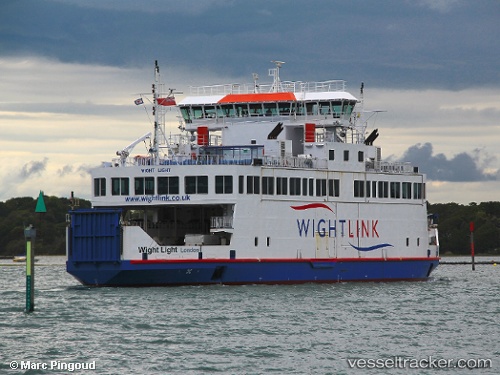
 Wight Light
Current Status
Where is the vessel?
Wight Light is currently in Near LYMINGTON, based on AIS data received less than 1h ago.
Latest AIS update:
Current position: 50.75857° N, 1.53055° W (Near LYMINGTON)
Average speed (last 7 days): Loading…
Average speed (last 30 days): Loading…
Vessel profile: Wight Light is a Passenger Ro Ro Cargo Ship with dimensions 62m x 60m.
This page combines live AIS, route history, probable destination signals, nearby traffic, and port activity for practical vessel monitoring.
The current position of vessel Wight Light is 50.75857 lat / -1.53055 lng. Updated: 2026-05-13 19:37:28 UTCNearest reference points:
- Near LYMINGTON
- Near Yarmouth
- Near Southampton
Currently sailing under the flag of United Kingdom ![]()
Wight Light built in 2008 year
Deadweight:
348 tDetails:
Live Vessel Wight Light Analytics (details, animations, etc.)
Recent AIS points (UTC):
2026-05-13 16:25:28 UTC · 50.75857, -1.53055 · SOG 0 kn · COG 155°2026-05-13 18:07:28 UTC · 50.75857, -1.53055 · SOG 0 kn · COG 155°
2026-05-13 19:05:02 UTC · 50.75857, -1.53056 · SOG 0 kn · COG 176°
2026-05-13 19:37:28 UTC · 50.75857, -1.53055 · SOG 0 kn · COG 155°