 vesseltracker.com
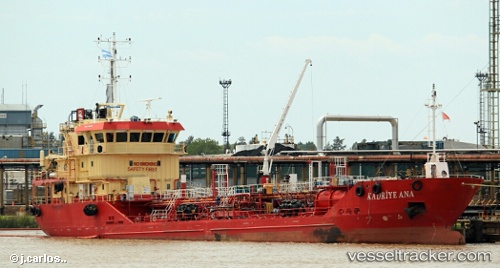
 KADRIYE ANA
Current Status
Where is the vessel?
KADRIYE ANA is currently in 39 nm SE of Kemer, based on AIS data received about 2h ago.
Latest AIS update:
Current position: 36.00500° N, 30.91833° E (39 nm SE of Kemer)
Average speed (last 7 days): Loading…
Average speed (last 30 days): Loading…
Vessel profile: KADRIYE ANA is a Chemical/Oil Products Tanker with dimensions 96m x 19m.
This page combines live AIS, route history, probable destination signals, nearby traffic, and port activity for practical vessel monitoring.
The current position of vessel KADRIYE ANA is 36.00500 lat / 30.91833 lng. Updated: 2026-04-09 01:47:13 UTCNearest reference points:
- Near Kemer
- Near Antalya Free Zone
- Near Antalya
Currently sailing under the flag of Turkey ![]()
KADRIYE ANA built in 2010 year
Deadweight:
2412 tDetails:
Live Vessel KADRIYE ANA Analytics (details, animations, etc.)
Recent AIS points (UTC):
2026-04-08 17:42:49 UTC · 36.02241, 29.71541 · SOG 7.2 kn · COG 90°2026-04-08 17:54:18 UTC · 36.01944, 29.74409 · SOG 7.2 kn · COG 90°
2026-04-08 17:54:18 UTC · 36.01944, 29.74409 · SOG 7.2 kn · COG 90°
2026-04-09 01:47:13 UTC · 36.00500, 30.91833 · SOG 6 kn · COG -1°