 vesseltracker.com
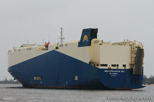
 Mediterranean Sea
Current Status
Where is the vessel?
Mediterranean Sea is currently in 190 nm E of Antofagasta, based on AIS data received less than 1h ago.
Latest AIS update:
Current position: 24.74044° S, 73.67493° E (190 nm E of Antofagasta)
Average speed (last 7 days): Loading…
Average speed (last 30 days): Loading…
Vessel profile: Mediterranean Sea is a Vehicles Carrier with dimensions 183m x 32m.
This page combines live AIS, route history, probable destination signals, nearby traffic, and port activity for practical vessel monitoring.
The current position of vessel Mediterranean Sea is -24.74044 lat / 73.67493 lng. Updated: 2026-05-16 11:48:53 UTCCurrently sailing under the flag of Marshall Is ![]()
Mediterranean Sea built in 2010 year
Deadweight:
14774 tDetails:
Live Vessel Mediterranean Sea Analytics (details, animations, etc.)
Recent AIS points (UTC):
2026-05-16 07:58:14 UTC · -24.36104, 74.59739 · SOG 14.8 kn · COG 243°2026-05-16 10:19:06 UTC · -24.59066, 74.03165 · SOG 14.3 kn · COG 243°
2026-05-16 10:34:48 UTC · -24.61808, 73.96948 · SOG 14.2 kn · COG 245°
2026-05-16 11:48:53 UTC · -24.74044, 73.67493 · SOG 14.2 kn · COG 248°