 vesseltracker.com
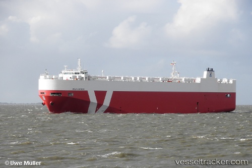
 Neptune Horizon
Current Status
Where is the vessel?
Neptune Horizon is currently in 26 nm SW of Piriápolis, based on AIS data received less than 1h ago.
Latest AIS update:
Current position: 35.21102° S, 55.60090° W (26 nm SW of Piriápolis)
Average speed (last 7 days): Loading…
Average speed (last 30 days): Loading…
Vessel profile: Neptune Horizon is a Vehicles Carrier with dimensions 168m x 28m.
This page combines live AIS, route history, probable destination signals, nearby traffic, and port activity for practical vessel monitoring.
The current position of vessel Neptune Horizon is -35.21102 lat / -55.60090 lng. Updated: 2026-04-17 01:18:24 UTCNearest reference points:
- 12 nm S of Piriápolis
- 16 nm N of Cabo San Antonio
- 21 nm E of PUNTA DEL ESTE
Currently sailing under the flag of Malta ![]()
Neptune Horizon built in 2010 year
Deadweight:
11215 tDetails:
Live Vessel Neptune Horizon Analytics (details, animations, etc.)
Recent AIS points (UTC):
2026-04-16 19:57:41 UTC · -35.21057, -55.60145 · SOG 0 kn · COG 64°2026-04-16 21:48:39 UTC · -35.21080, -55.60123 · SOG 0.1 kn · COG 68°
2026-04-17 00:03:43 UTC · -35.21092, -55.60090 · SOG 0 kn · COG 42°
2026-04-17 01:18:24 UTC · -35.21102, -55.60090 · SOG 0 kn · COG -1°