 vesseltracker.com
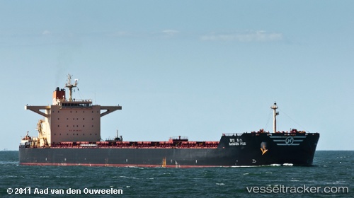
 CAPE GOOD HOPE
Current Status
Where is the vessel?
CAPE GOOD HOPE is currently in 13 nm N of Port Hedland, based on AIS data received less than 1h ago.
Latest AIS update:
Current position: 20.08412° S, 118.63462° E (13 nm N of Port Hedland)
Average speed (last 7 days): Loading…
Average speed (last 30 days): Loading…
Vessel profile: CAPE GOOD HOPE is a Bulk Carrier with dimensions m x m.
This page combines live AIS, route history, probable destination signals, nearby traffic, and port activity for practical vessel monitoring.
The current position of vessel CAPE GOOD HOPE is -20.08412 lat / 118.63462 lng. Updated: 2026-04-23 20:02:18 UTCNearest reference points:
- 11 nm E of Port Walcot
- 116 nm NE of Mutineer
- 121 nm NE of Mutineer
Currently sailing under the flag of Liberia ![]()
Details:
Live Vessel CAPE GOOD HOPE Analytics (details, animations, etc.)
Recent AIS points (UTC):
2026-04-23 16:45:23 UTC · -19.98665, 118.49887 · SOG 10.2 kn · COG 148°2026-04-23 18:02:03 UTC · -20.08267, 118.61335 · SOG 4.8 kn · COG 105°
2026-04-23 19:23:16 UTC · -20.08412, 118.63455 · SOG 0.1 kn · COG 218°
2026-04-23 20:02:18 UTC · -20.08412, 118.63462 · SOG 0.1 kn · COG 220°