 vesseltracker.com
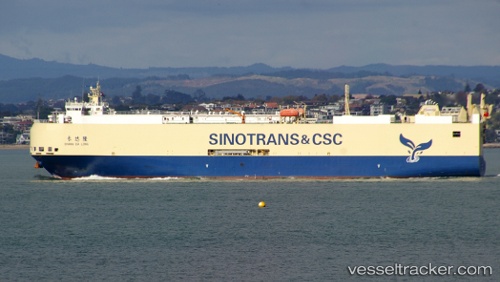
 Chang Da Long
Current Status
Where is the vessel?
Chang Da Long is currently in 278 nm E of Tan Cang Qui Nhon, based on AIS data received about 4h ago.
Latest AIS update:
Current position: 13.76833° N, 114.59833° E (278 nm E of Tan Cang Qui Nhon)
Average speed (last 7 days): Loading…
Average speed (last 30 days): Loading…
Vessel profile: Chang Da Long is a Vehicles Carrier with dimensions 141m x 141m.
This page combines live AIS, route history, probable destination signals, nearby traffic, and port activity for practical vessel monitoring.
The current position of vessel Chang Da Long is 13.76833 lat / 114.59833 lng. Updated: 2026-04-30 03:46:11 UTCNearest reference points:
- 282 nm E of Tan Cang Qui Nhon
- 232 nm E of Tan Cang Qui Nhon
- 222 nm E of Tan Cang Qui Nhon
Currently sailing under the flag of China ![]()
Chang Da Long built in 2012 year
Deadweight:
5837 tDetails:
Live Vessel Chang Da Long Analytics (details, animations, etc.)
Recent AIS points (UTC):
2026-04-30 01:52:08 UTC · 13.44167, 114.31167 · SOG 13 kn · COG -1°2026-04-30 02:04:12 UTC · 13.47500, 114.34167 · SOG 13 kn · COG -1°
2026-04-30 03:46:11 UTC · 13.76833, 114.59833 · SOG 13 kn · COG -1°
2026-04-30 03:46:11 UTC · 13.76833, 114.59833 · SOG 13 kn · COG -1°