 vesseltracker.com
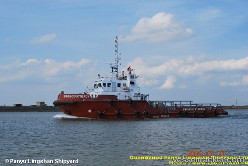
 NILOFAR
Current Status
Where is the vessel?
NILOFAR is currently in 29 nm N of Abu al Bukhoosh, based on AIS data received less than 1h ago.
Latest AIS update:
Current position: 25.97290° N, 53.15407° E (29 nm N of Abu al Bukhoosh)
Average speed (last 7 days): Loading…
Average speed (last 30 days): Loading…
Vessel profile: NILOFAR is a Offshore Tug/Supply Ship with dimensions 10m x 36m.
This page combines live AIS, route history, probable destination signals, nearby traffic, and port activity for practical vessel monitoring.
The current position of vessel NILOFAR is 25.97290 lat / 53.15407 lng. Updated: 2026-04-25 14:15:04 UTCNearest reference points:
- 21 nm NE of Halul Island
- Near Jazireh-Ye Lavan
- Near Das Island
Currently sailing under the flag of Tanzania ![]()
NILOFAR built in 2009 year
Deadweight:
350 tDetails:
Live Vessel NILOFAR Analytics (details, animations, etc.)
Recent AIS points (UTC):
2026-04-25 10:59:10 UTC · 25.97281, 53.15381 · SOG 1 kn · COG 0°2026-04-25 11:25:45 UTC · 25.97284, 53.15389 · SOG 0.3 kn · COG 0°
2026-04-25 13:40:07 UTC · 25.97288, 53.15404 · SOG 0.5 kn · COG 0°
2026-04-25 14:15:04 UTC · 25.97290, 53.15407 · SOG 0 kn · COG 0°