 vesseltracker.com
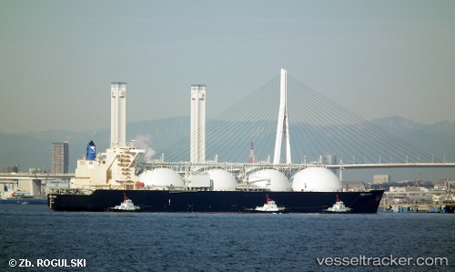
Energy Horizon
Current StatusWhere is the vessel?
Energy Horizon is currently in Near Naka-Ku, Kanagawa, based on AIS data received less than 1h ago.
Latest AIS update:
Current position: 35.40024° N, 139.63483° E (Near Naka-Ku, Kanagawa)
Average speed (last 7 days): Loading…
Average speed (last 30 days): Loading…
Vessel profile: Energy Horizon is a Lng Tanker with dimensions 52m x 300m.
This page combines live AIS, route history, probable destination signals, nearby traffic, and port activity for practical vessel monitoring.
The current position of vessel Energy Horizon is 35.40024 lat / 139.63483 lng. Updated: 2026-05-01 03:29:13 UTCNearest reference points:
- Near Naka-Ku, Kanagawa
- Near Yokohama
- Near Kawasaki
Details:
Live Vessel Energy Horizon Analytics (details, animations, etc.)
Recent AIS points (UTC):
2026-05-01 00:16:10 UTC · 35.18087, 139.77852 · SOG 9.6 kn · COG 5°2026-05-01 01:38:29 UTC · 35.38647, 139.68344 · SOG 7.8 kn · COG 310°
2026-05-01 01:48:41 UTC · 35.39867, 139.66370 · SOG 5.8 kn · COG 280°
2026-05-01 03:29:13 UTC · 35.40024, 139.63483 · SOG 0 kn · COG 257°