 vesseltracker.com
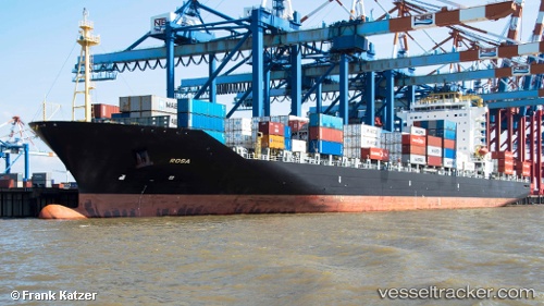
 JOLLY ROSA
Current Status
Where is the vessel?
JOLLY ROSA is currently in 42 nm SE of Pemba, based on AIS data received about 1h ago.
Latest AIS update:
Current position: 13.39500° S, 41.05167° E (42 nm SE of Pemba)
Average speed (last 7 days): Loading…
Average speed (last 30 days): Loading…
Vessel profile: JOLLY ROSA is a Container Ship with dimensions m x m.
This page combines live AIS, route history, probable destination signals, nearby traffic, and port activity for practical vessel monitoring.
The current position of vessel JOLLY ROSA is -13.39500 lat / 41.05167 lng. Updated: 2026-05-14 06:01:15 UTCNearest reference points:
- 10 nm N of NACALA PORTO
- Near NACALA PORTO
- 47 nm NW of Mohéli Apt
Currently sailing under the flag of Italy ![]()
Details:
Live Vessel JOLLY ROSA Analytics (details, animations, etc.)
Recent AIS points (UTC):
2026-05-14 02:50:21 UTC · -14.17940, 41.05949 · SOG 14.4 kn · COG 1°2026-05-14 03:49:16 UTC · -13.93500, 41.05833 · SOG 14 kn · COG -1°
2026-05-14 05:01:14 UTC · -13.63833, 41.05667 · SOG 14 kn · COG -1°
2026-05-14 06:01:15 UTC · -13.39500, 41.05167 · SOG 14 kn · COG -1°