 vesseltracker.com
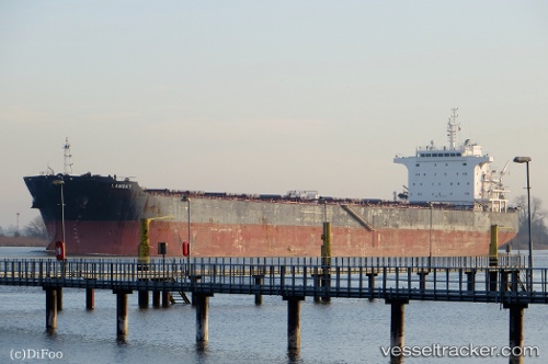
 Lambay
Current Status
Where is the vessel?
Lambay is currently in Near GUISHAN, based on AIS data received about 1h ago.
Latest AIS update:
Current position: 22.08239° N, 113.89972° E (Near GUISHAN)
Average speed (last 7 days): Loading…
Average speed (last 30 days): Loading…
Vessel profile: Lambay is a Bulk Carrier with dimensions 225m x 225m.
This page combines live AIS, route history, probable destination signals, nearby traffic, and port activity for practical vessel monitoring.
The current position of vessel Lambay is 22.08239 lat / 113.89972 lng. Updated: 2026-04-27 22:02:54 UTCNearest reference points:
- Near WAILINGDING ISLAND
- Near GUISHAN
- Near Cheung Sha Wan
Currently sailing under the flag of Liberia ![]()
Lambay built in 2011 year
Deadweight:
75200 tDetails:
Live Vessel Lambay Analytics (details, animations, etc.)
Recent AIS points (UTC):
2026-04-27 19:44:47 UTC · 22.08245, 113.89988 · SOG 0 kn · COG 106°2026-04-27 20:23:49 UTC · 22.08231, 113.89968 · SOG 0 kn · COG 108°
2026-04-27 21:29:54 UTC · 22.08248, 113.89978 · SOG 0 kn · COG 113°
2026-04-27 22:02:54 UTC · 22.08239, 113.89972 · SOG 0 kn · COG 109°