 vesseltracker.com
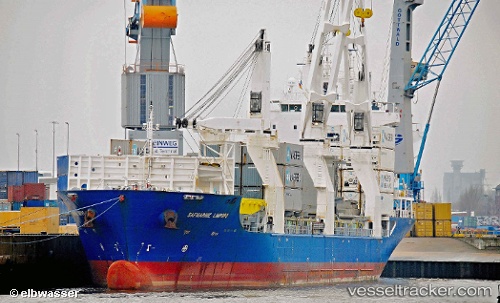
 CONDOR PATAGONIA
Current Status
Where is the vessel?
CONDOR PATAGONIA is currently in 103 nm N of Adventure, based on AIS data received less than 1h ago.
Latest AIS update:
Current position: 8.68167° N, 59.09500° W (103 nm N of Adventure)
Average speed (last 7 days): Loading…
Average speed (last 30 days): Loading…
Vessel profile: CONDOR PATAGONIA is a General Cargo Ship with dimensions 22m x 140m.
This page combines live AIS, route history, probable destination signals, nearby traffic, and port activity for practical vessel monitoring.
The current position of vessel CONDOR PATAGONIA is 8.68167 lat / -59.09500 lng. Updated: 2026-05-14 17:26:40 UTCNearest reference points:
- 57 nm NE of Adventure
- 16 nm E of Galeota Point
- Near POINT LISAS
Currently sailing under the flag of Antigua and Barbuda ![]()
CONDOR PATAGONIA built in 2010 year
Deadweight:
12337 tDetails:
Live Vessel CONDOR PATAGONIA Analytics (details, animations, etc.)
Recent AIS points (UTC):
2026-05-14 13:41:42 UTC · 9.31167, -59.50333 · SOG 11 kn · COG -1°2026-05-14 15:44:39 UTC · 8.97333, -59.27667 · SOG 11 kn · COG -1°
2026-05-14 16:17:42 UTC · 8.87893, -59.22104 · SOG 12.2 kn · COG 144°
2026-05-14 17:26:40 UTC · 8.68167, -59.09500 · SOG 12 kn · COG -1°