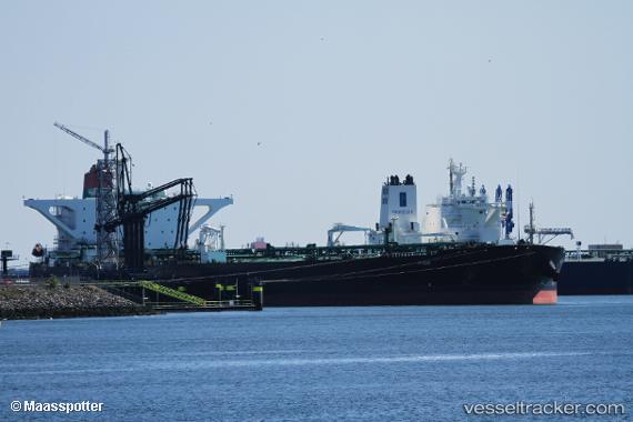
.
Vessel photo of Fida (IMO 9501150) vesseltracker.com

Fida

Vessel type: Crude Oil Tanker | IMO: 9501150 | MMSI: MMSI: 538004633
Call sign: V7YD5 | Dimensions: 60 m x 333 m
Current Status

Where is the vessel?

Fida is currently in 56 nm SW of Rabigh, based on AIS data received about 16h ago.

Latest AIS update:

Current position: 22.33717° N, 38.05888° E (56 nm SW of Rabigh)

Average speed (last 7 days): Loading…

Average speed (last 30 days): Loading…

Vessel profile: Fida is a Crude Oil Tanker with dimensions 60m x 333m.

This page combines live AIS, route history, probable destination signals, nearby traffic, and port activity for practical vessel monitoring.

The current position of vessel Fida is 22.33717 lat / 38.05888 lng. Updated: 2026-03-29 15:46:35 UTC
Nearest reference points:
  • 65 nm SW of King Abdullah City
  • 67 nm W of Tusdeer Free Zone
  • 64 nm W of Tusdeer Free Zone
Details:

Live Vessel Fida Analytics (details, animations, etc.)


Recent AIS points (UTC):
2026-03-29 14:21:07 UTC · 22.33152, 38.04984 · SOG 0.5 kn · COG 242°
2026-03-29 15:42:38 UTC · 22.33717, 38.05888 · SOG 0.2 kn · COG -1°
2026-03-29 15:46:35 UTC · 22.33717, 38.05888 · SOG 0.2 kn · COG -1°

Track of the vessel in the last 28 days


UTC: --
Start: -- Track timeline (UTC) End: --
Encountered: --


Link to the map:


Find another ship

Fida (538004633) last ports (portcalls and passsages)

PENGERANG | 2025-08-24 07:57:35
TANAH MERAH | 2025-08-24 06:05:58
PULAU SAMBU | 2025-08-24 05:12:44
Port Louis | 2025-08-11 03:25:25
BUKOM ISLAND | 2025-06-05 12:25:17
BATU AMPAR | 2025-06-03 17:12:58
TANAH MERAH | 2025-06-03 16:23:05
PENGERANG | 2025-06-03 14:58:34
TANAH MERAH | 2025-05-25 08:19:30
PENGERANG | 2025-05-25 07:01:09
PENGERANG | 2025-04-30 21:29:38
TANAH MERAH | 2025-04-30 20:23:57
PULAU SAMBU | 2025-04-30 19:03:43
Port Louis | 2025-04-19 03:48:36
Durban | 2024-12-08 06:27:52
Walvisbaai | 2024-10-03 16:26:19
Singapore | 2024-09-06 22:48:16
Singapore | 2024-08-17 10:46:11
Cape Lopez | 2024-07-14 05:21:22
Cape Lopez | 2024-07-10 04:45:04
Cape Lopez | 2024-07-06 04:41:19
Algeciras | 2024-06-21 03:15:22
Strait Of Gibraltar | 2024-06-20 23:36:50
Terneuzen | 2024-06-11 19:16:58
Vlissingen | 2024-06-11 17:57:29
Zeebrugge | 2024-06-11 15:59:28
Maassluis | 2024-06-05 14:12:27
Vlaardingen | 2024-04-03 03:40:18
Maassluis | 2024-04-02 15:35:15
Vlaardingen | 2024-03-29 15:13:22
Maassluis | 2024-03-29 14:21:02
Singapore | 2023-12-06 20:45:34
Sambu | 2023-11-30 15:03:11
Singapore | 2023-11-10 22:55:35
Singapore | 2023-10-17 07:16:16
Singapore | 2023-09-14 09:32:28
Singapore | 2023-08-10 07:32:01
Pointe Noire | 2023-07-12 02:15:43
Pointe Noire | 2023-07-08 02:05:49
Singapore | 2023-06-07 22:58:49
Singapore | 2023-05-13 23:40:43
Gothenburg | 2023-03-24 08:14:09
Skagens Odde | 2023-01-23 20:47:27
Skagens Odde | 2023-01-02 09:03:20
Leith | 2022-12-31 08:25:39
Rosyth | 2022-12-28 06:05:31
Port Said | 2022-11-21 17:16:55
Ayn Sukhnah | 2022-11-18 20:42:02
Ras Tannurah | 2022-11-05 15:07:17
Singapore | 2022-10-17 01:16:56
Singapore | 2022-10-12 16:02:38
Mutrah | 2022-09-09 16:57:44
Singapore | 2022-08-21 16:16:27
Sambu | 2022-07-28 02:47:18
Singapore | 2022-06-21 07:32:02
Sambu | 2022-06-21 07:13:49
Long Beach | 2022-02-19 18:40:39
Sambu | 2022-01-10 10:00:42
Singapore | 2022-01-10 09:20:01
Sambu | 2022-01-10 09:11:02
Singapore | 2021-12-02 20:45:05
Sambu | 2021-12-02 20:15:27