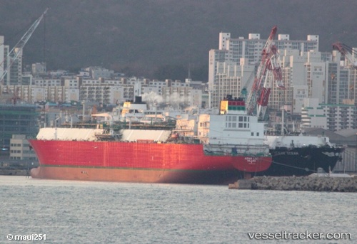
.
Vessel photo of Adam Lng (IMO 9501186) vesseltracker.com

MH flag Adam Lng

Vessel type: Lng Tanker | IMO: 9501186 | MMSI: MMSI: 538005753
Call sign: V7GR3 | Dimensions: 289 m x 46 m
Current Status

Where is the vessel?

Adam Lng is currently in 38 nm SE of Morant Bay, based on AIS data received about 1d ago.

Latest AIS update:

Current position: 17.60500° N, 75.82333° W (38 nm SE of Morant Bay)

Average speed (last 7 days): Loading…

Average speed (last 30 days): Loading…

Vessel profile: Adam Lng is a Lng Tanker with dimensions 289m x 46m.

This page combines live AIS, route history, probable destination signals, nearby traffic, and port activity for practical vessel monitoring.

The current position of vessel Adam Lng is 17.60500 lat / -75.82333 lng. Updated: 2026-04-10 07:15:06 UTC
Nearest reference points:
  • 16 nm SE of Ceiba Hueca

Currently sailing under the flag of Marshall Is MH flag

Details:

Live Vessel Adam Lng Analytics (details, animations, etc.)


Recent AIS points (UTC):
2026-04-10 02:21:08 UTC · 17.82330, -76.72335 · SOG 8.9 kn · COG 345°
2026-04-10 04:18:05 UTC · 17.80667, -76.64833 · SOG 14 kn · COG -1°
2026-04-10 06:09:07 UTC · 17.69500, -76.13500 · SOG 17 kn · COG -1°
2026-04-10 07:15:06 UTC · 17.60500, -75.82333 · SOG 16 kn · COG -1°

Track of the vessel in the last 60 days


UTC: --
Start: -- Track timeline (UTC) End: --
Encountered: --


Link to the map:


Find another ship

Adam_Lng (538005753) last ports (portcalls and passsages)

KATTUPALLI | 2025-08-02 01:57:15
ENNORE | 2025-08-02 00:43:35
Port Louis | 2025-07-26 08:03:17
CAMERON | 2025-06-30 22:19:08
KATTUPALLI | 2025-05-26 01:23:35
CAMERON | 2025-04-23 18:13:35
Port Louis | 2025-03-23 03:46:07
KATTUPALLI | 2025-03-15 01:22:33
CAMERON | 2025-02-11 18:39:45
KATTUPALLI | 2025-01-04 04:36:24
ENNORE | 2025-01-04 03:38:49
CAMERON | 2024-12-02 07:03:01
Port Louis | 2024-11-07 03:46:41
Cochin | 2024-08-18 06:01:51
Cochin | 2024-08-14 05:47:49
Port Louis | 2024-06-02 01:40:13
Malabo | 2024-05-18 04:29:22
Puerto De La Luz | 2024-05-08 06:39:46
Zeebrugge | 2024-05-01 14:14:47
Port Louis | 2024-04-05 16:50:54
Singapore | 2024-03-08 09:14:25
Thursday Island | 2024-02-26 13:01:26
Gladstone Harbor | 2024-02-21 13:14:32
Torres Strait | 2024-02-13 22:20:45
Selat Wetar | 2024-02-10 08:58:46
Singapore | 2024-02-03 23:36:53
Selat Lombok | 2024-02-01 02:03:32
Barrow Island | 2024-01-29 04:50:26
Sambu | 2024-01-05 11:02:22
Ra’S Shukhayr | 2023-12-23 00:55:03
Ras Gharib | 2023-12-22 23:25:16
Bur Ibrahim | 2023-12-22 15:50:58
Port Said | 2023-12-18 14:52:45
Bur Ibrahim | 2023-12-18 05:03:08
Ra’S Shukhayr | 2023-12-17 01:30:23
Muhammad Bin Qasim | 2023-12-07 11:23:23
Ras Gharib | 2023-11-25 06:24:26
Bur Ibrahim | 2023-11-24 23:17:34
Port Said | 2023-11-24 13:55:13
Bur Ibrahim | 2023-11-14 10:15:53
Muhammad Bin Qasim | 2023-11-05 05:47:15
Ras Gharib | 2023-10-29 00:59:14
Bur Ibrahim | 2023-10-28 18:31:54
Port Said | 2023-10-28 08:46:34
Strait Of Gibraltar | 2023-10-22 10:41:23
Brighton | 2023-10-13 21:44:38
St. Nazaire | 2023-09-25 11:18:53
Singapore | 2023-06-20 23:04:04
Sambu | 2023-06-20 22:17:17
Thursday Island | 2023-06-13 17:41:35
Gladstone Harbor | 2023-04-26 19:53:04
Singapore | 2023-04-05 04:43:47
Nemrut Bay | 2023-02-04 06:02:08
Kingston | 2023-01-06 17:28:45
Milford Haven | 2022-12-13 21:00:44
Strait Of Gibraltar | 2022-09-18 14:00:15
Algeciras | 2022-09-14 16:36:42
Algeciras | 2022-09-10 16:05:28
Algeciras | 2022-09-06 13:55:16
Algeciras | 2022-09-02 13:13:37
Algeciras | 2022-08-29 13:03:54
Valletta | 2022-08-25 10:26:05
Marsaxlokk | 2022-08-25 07:33:06
Port Said | 2022-07-29 17:03:06
Bur Ibrahim | 2022-07-29 07:12:28
Ra’S Shukhayr | 2022-07-28 01:10:11
Mina Saud | 2022-07-17 04:23:33
Bonny | 2022-06-24 08:02:49
Port Louis | 2022-06-05 04:59:42
Singapore | 2022-05-26 04:44:58
Bur Ibrahim | 2022-05-06 16:02:07
Livorno | 2022-03-21 09:05:47
Strait Of Gibraltar | 2022-01-08 23:40:15
Algeciras | 2022-01-08 13:05:17
Botas | 2021-12-28 14:05:16
Strait Of Gibraltar | 2021-12-05 18:55:01
Zeebrugge | 2021-12-01 00:00:38