 vesseltracker.com
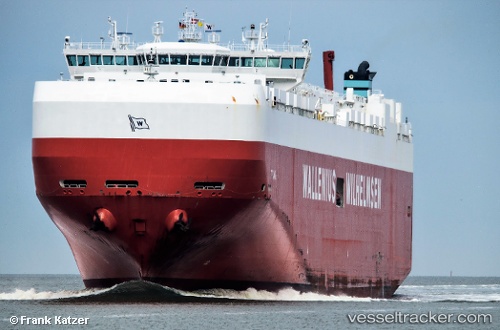
 Titania
Current Status
Where is the vessel?
Titania is currently in Near Southampton, based on AIS data received less than 1h ago.
Latest AIS update:
Current position: 50.89177° N, 1.39876° W (Near Southampton)
Average speed (last 7 days): Loading…
Average speed (last 30 days): Loading…
Vessel profile: Titania is a Vehicles Carrier with dimensions 231m x 32m.
This page combines live AIS, route history, probable destination signals, nearby traffic, and port activity for practical vessel monitoring.
The current position of vessel Titania is 50.89177 lat / -1.39876 lng. Updated: 2026-05-14 07:22:16 UTCNearest reference points:
- Near Southampton
- Near MERCURY
- Near PORT HAMBLE
Currently sailing under the flag of Malta ![]()
Titania built in 2011 year
Deadweight:
30907 tDetails:
Live Vessel Titania Analytics (details, animations, etc.)
Recent AIS points (UTC):
2026-05-14 04:13:45 UTC · 50.88419, -1.39946 · SOG 2.9 kn · COG 316°2026-05-14 06:19:09 UTC · 50.89177, -1.39875 · SOG 0 kn · COG 12°
2026-05-14 07:01:13 UTC · 50.89177, -1.39876 · SOG 0 kn · COG 12°
2026-05-14 07:22:16 UTC · 50.89177, -1.39876 · SOG 0 kn · COG 12°