 vesseltracker.com
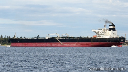
Mount Fuji
Current StatusWhere is the vessel?
Mount Fuji is currently in Near Akcansa, based on AIS data received less than 1h ago.
Latest AIS update:
Current position: 40.03167° N, 26.19972° E (Near Akcansa)
Average speed (last 7 days): Loading…
Average speed (last 30 days): Loading…
Vessel profile: Mount Fuji is a Crude Oil Tanker with dimensions 50m x 274m.
This page combines live AIS, route history, probable destination signals, nearby traffic, and port activity for practical vessel monitoring.
The current position of vessel Mount Fuji is 40.03167 lat / 26.19972 lng. Updated: 2026-04-28 13:07:12 UTCNearest reference points:
- 10 nm W of Akcansa
- Near Bozcaada
- Near Akcansa
Details:
Live Vessel Mount Fuji Analytics (details, animations, etc.)
Recent AIS points (UTC):
2026-04-28 10:12:33 UTC · 40.41720, 26.71885 · SOG 5.4 kn · COG 233°2026-04-28 10:14:03 UTC · 40.41575, 26.71652 · SOG 5.5 kn · COG 235°
2026-04-28 12:09:22 UTC · 40.14925, 26.38668 · SOG 13.3 kn · COG 182°
2026-04-28 13:07:12 UTC · 40.03167, 26.19972 · SOG 9.4 kn · COG 250°