 vesseltracker.com
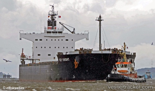
 KEY KNIGHT
Current Status
Where is the vessel?
KEY KNIGHT is currently in 47 nm E of Margonin, based on AIS data received about 2h ago.
Latest AIS update:
Current position: 52.96167° N, 177.29167° E (47 nm E of Margonin)
Average speed (last 7 days): Loading…
Average speed (last 30 days): Loading…
Vessel profile: KEY KNIGHT is a Bulk Carrier with dimensions 32m x 229m.
This page combines live AIS, route history, probable destination signals, nearby traffic, and port activity for practical vessel monitoring.
The current position of vessel KEY KNIGHT is 52.96167 lat / 177.29167 lng. Updated: 2026-05-15 01:23:23 UTCNearest reference points:
- 87 nm NE of Margonin
Currently sailing under the flag of Liberia ![]()
KEY KNIGHT built in 2012 year
Deadweight:
82099 tDetails:
Live Vessel KEY KNIGHT Analytics (details, animations, etc.)
Recent AIS points (UTC):
2026-05-14 22:09:25 UTC · 53.05455, 178.20020 · SOG 10.5 kn · COG 261°2026-05-14 22:09:25 UTC · 53.05455, 178.20020 · SOG 10.5 kn · COG 261°
2026-05-14 23:20:21 UTC · 53.02167, 177.86166 · SOG 10 kn · COG -1°
2026-05-15 01:23:23 UTC · 52.96167, 177.29167 · SOG 10 kn · COG -1°