 vesseltracker.com
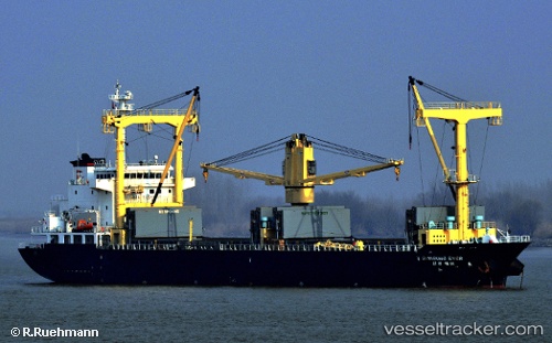
 Shinsung Ever
Current Status
Where is the vessel?
Shinsung Ever is currently in 12 nm E of Wipro Sez/Resapuvanipalem, based on AIS data received less than 1h ago.
Latest AIS update:
Current position: 17.67057° N, 83.52278° E (12 nm E of Wipro Sez/Resapuvanipalem)
Average speed (last 7 days): Loading…
Average speed (last 30 days): Loading…
Vessel profile: Shinsung Ever is a General Cargo Ship with dimensions 127m x 22m.
This page combines live AIS, route history, probable destination signals, nearby traffic, and port activity for practical vessel monitoring.
The current position of vessel Shinsung Ever is 17.67057 lat / 83.52278 lng. Updated: 2026-05-14 00:58:53 UTCNearest reference points:
- Near Wipro Sez/Resapuvanipalem
- Near Vishakhapatnam
- Near Gopalpur
Currently sailing under the flag of Korea ![]()
Shinsung Ever built in 2011 year
Deadweight:
14706 tDetails:
Live Vessel Shinsung Ever Analytics (details, animations, etc.)
Recent AIS points (UTC):
2026-05-13 21:58:53 UTC · 17.67187, 83.52193 · SOG 0.1 kn · COG 167°2026-05-13 22:43:53 UTC · 17.67143, 83.52250 · SOG 0.1 kn · COG 194°
2026-05-13 23:19:53 UTC · 17.67140, 83.52257 · SOG 0 kn · COG 198°
2026-05-14 00:58:53 UTC · 17.67057, 83.52278 · SOG 0.2 kn · COG 297°