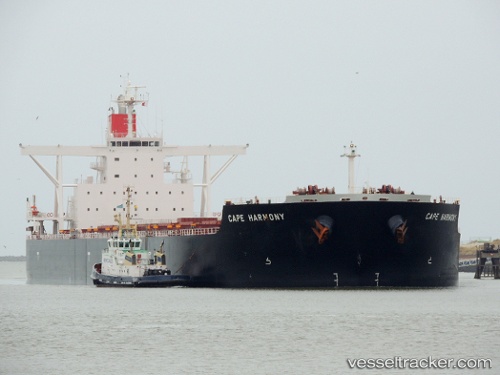
.
Vessel photo of Cape Harmony (IMO 9514212) vesseltracker.com

PA flag Cape Harmony

Vessel type: Bulk Carrier | IMO: 9514212 | MMSI: MMSI: 373009000
Call sign: 3FIB3 | Dimensions: 292 m x 45 m
Current Status

Where is the vessel?

Cape Harmony is currently in 376 nm S of Bela Vista, based on AIS data received less than 1h ago.

Latest AIS update:

Current position: 28.01938° S, 32.67783° W (376 nm S of Bela Vista)

Average speed (last 7 days): Loading…

Average speed (last 30 days): Loading…

Vessel profile: Cape Harmony is a Bulk Carrier with dimensions 292m x 45m.

This page combines live AIS, route history, probable destination signals, nearby traffic, and port activity for practical vessel monitoring.

The current position of vessel Cape Harmony is -28.01938 lat / -32.67783 lng. Updated: 2026-04-07 19:37:45 UTC
Nearest reference points:
  • 311 nm NE of Burzaco

Currently sailing under the flag of Panama PA flag

Cape Harmony built in 2012 year

Deadweight:
178373 t

Details:

Live Vessel Cape Harmony Analytics (details, animations, etc.)


Recent AIS points (UTC):
2026-04-07 14:09:31 UTC · -27.66264, -33.67631 · SOG 10.7 kn · COG 117°
2026-04-07 15:56:01 UTC · -27.79287, -33.35518 · SOG 10.3 kn · COG 116°
2026-04-07 17:36:42 UTC · -27.89944, -33.05113 · SOG 10.5 kn · COG 110°
2026-04-07 19:37:45 UTC · -28.01938, -32.67783 · SOG 10.2 kn · COG 111°

Track of the vessel in the last 60 days


UTC: --
Start: -- Track timeline (UTC) End: --
Encountered: --


Link to the map:


Find another ship

Cape_Harmony (373009000) last ports (portcalls and passsages)

SEPT-ILES | 2025-08-04 19:06:42
BRIELLE | 2025-07-20 19:55:55
BRIELLE | 2025-07-16 19:53:20
HOEK VAN HOLLAND | 2025-07-16 18:57:13
Puerto De La Luz | 2025-07-07 20:08:09
Puerto De La Luz | 2025-07-03 19:48:16
ESQUIMALT | 2025-05-15 11:11:55
Vancouver | 2025-05-14 12:10:02
Vancouver | 2025-05-10 11:38:21
TSAWWASSEN | 2025-05-10 09:13:35
Vancouver | 2025-05-06 10:53:35
TSAWWASSEN | 2025-05-06 08:32:09
Tsugaru-Kaikyo | 2025-04-20 05:58:36
Yosu | 2025-04-17 10:59:22
Yosu | 2025-04-10 20:58:24
DALRYMPLE | 2025-03-24 21:25:10
SUMOTO | 2025-03-03 12:30:16
TAKASAGO | 2025-02-27 13:01:30
TAKASAGO | 2025-02-23 12:58:36
AKASHI | 2025-02-23 10:58:40
KADA | 2025-02-23 08:22:21
PORT WALCOTT | 2025-02-08 04:34:14
Samson Point | 2025-02-08 03:59:22
Selat Lombok | 2025-01-29 19:16:07
HULUDAO | 2025-01-01 05:09:53
JINGTANG | 2024-12-26 08:20:02
PORT WALCOTT | 2024-12-08 09:34:02
Samson Point | 2024-12-08 08:49:25
Selat Lombok | 2024-12-02 14:49:32
San Nicolas | 2024-10-01 10:51:43
San Nicolas | 2024-09-27 09:50:47
San Nicolas | 2024-09-23 09:41:17
Tsugaru-Kaikyo | 2024-08-19 13:42:51
Pohang | 2024-08-15 15:00:09
Yosu | 2024-08-09 06:58:49
Newcastle | 2024-07-16 22:41:13
Yosu | 2024-06-24 02:49:41
Yosu | 2024-06-19 05:14:29
Sambu | 2024-06-02 17:23:24
Maassluis | 2024-03-13 10:56:17
Maassluis | 2024-03-09 10:36:27
Maassluis | 2024-03-05 10:09:32
Puerto De La Luz | 2024-02-16 06:18:59
Singapore | 2024-01-05 15:15:25
Sambu | 2024-01-05 14:12:37
Samson Point | 2023-10-27 01:12:13
Tai-tung Kang | 2023-10-15 20:55:14
Tai-tung Kang | 2023-10-11 20:26:39
Kaohsiung | 2023-10-08 05:01:28
Kaohsiung | 2023-10-01 00:41:39
Selat Lombok | 2023-09-23 07:05:09
Samson Point | 2023-09-18 20:01:17
Newcastle | 2023-08-16 05:39:46
Taicang | 2023-07-25 12:59:06
Zhangjiagang | 2023-07-24 02:09:55
Nantong | 2023-07-23 23:14:16
Wusong | 2023-07-23 19:35:15
Jingjiang | 2023-07-23 13:39:41
Lianyungang | 2023-07-18 03:00:04
Singapore | 2023-07-07 15:55:28
Sambu | 2023-07-07 15:24:09
Bur Ibrahim | 2023-03-30 16:59:33
Bur Ibrahim | 2022-11-22 05:11:29
Ra’S Shukhayr | 2022-11-20 20:06:17
Nagoya | 2022-09-28 04:33:42
Ube | 2022-09-26 04:39:49
Wakamatsu | 2022-09-24 16:37:28
Wakamatsu | 2022-09-20 13:36:42
Wakamatsu | 2022-09-15 13:16:56
Newcastle | 2022-08-25 07:18:29
Singapore | 2022-07-12 16:43:26
Ra’S Shukhayr | 2022-06-22 02:08:03
Strait Of Gibraltar | 2022-06-13 17:04:10
Dunkerque | 2022-05-05 16:25:22
Calais | 2022-05-05 07:02:43
Yosu | 2021-12-30 05:34:32
Port Headland | 2021-12-12 04:38:25