 vesseltracker.com
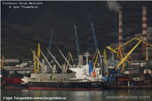
 Serene Sky
Current Status
Where is the vessel?
Serene Sky is currently in 14 nm SE of ZHOUSHAN, based on AIS data received less than 1h ago.
Latest AIS update:
Current position: 29.77494° N, 122.36314° E (14 nm SE of ZHOUSHAN)
Average speed (last 7 days): Loading…
Average speed (last 30 days): Loading…
Vessel profile: Serene Sky is a Bulk Carrier with dimensions 190m x 189m.
This page combines live AIS, route history, probable destination signals, nearby traffic, and port activity for practical vessel monitoring.
The current position of vessel Serene Sky is 29.77494 lat / 122.36314 lng. Updated: 2026-05-15 14:21:52 UTCNearest reference points:
- 12 nm SE of ZHOUSHAN
- 16 nm SE of ZHOUSHAN
- Near ZHOUSHAN
Currently sailing under the flag of Panama ![]()
Serene Sky built in 2011 year
Deadweight:
56119 tDetails:
Live Vessel Serene Sky Analytics (details, animations, etc.)
Recent AIS points (UTC):
2026-05-15 10:22:44 UTC · 29.77110, 122.35633 · SOG 0.7 kn · COG 114°2026-05-15 12:09:32 UTC · 29.77494, 122.36149 · SOG 3.9 kn · COG 135°
2026-05-15 13:27:51 UTC · 29.77558, 122.36124 · SOG 0.4 kn · COG 179°
2026-05-15 14:21:52 UTC · 29.77494, 122.36314 · SOG 0.3 kn · COG 202°