 vesseltracker.com
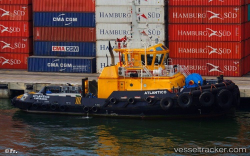
Atlantico
Current StatusWhere is the vessel?
Atlantico is currently in Near Santa Marta, based on AIS data received less than 1h ago.
Latest AIS update:
Current position: 11.25068° N, 74.21552° W (Near Santa Marta)
Average speed (last 7 days): Loading…
Average speed (last 30 days): Loading…
Vessel profile: Atlantico is a Tug with dimensions 12m x 32m.
This page combines live AIS, route history, probable destination signals, nearby traffic, and port activity for practical vessel monitoring.
The current position of vessel Atlantico is 11.25068 lat / -74.21552 lng. Updated: 2026-05-14 18:04:55 UTCNearest reference points:
- Near Santa Marta
- 18 nm N of Santa Marta
- Near Contecar
Details:
Live Vessel Atlantico Analytics (details, animations, etc.)
Recent AIS points (UTC):
2026-05-14 14:13:44 UTC · 11.25120, -74.21541 · SOG 0.1 kn · COG 21°2026-05-14 16:20:55 UTC · 11.25122, -74.21543 · SOG 0 kn · COG 21°
2026-05-14 16:50:06 UTC · 11.25121, -74.21542 · SOG 0 kn · COG 21°
2026-05-14 18:04:55 UTC · 11.25068, -74.21552 · SOG 0 kn · COG 200°