 vesseltracker.com
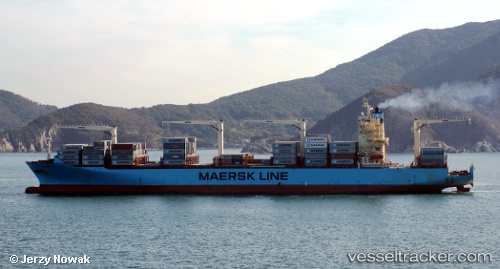
Maersk Conakry
Current StatusWhere is the vessel?
Maersk Conakry is currently in 71 nm NE of KIJANG, based on AIS data received about 5h ago.
Latest AIS update:
Current position: 1.85017° N, 105.26367° E (71 nm NE of KIJANG)
Average speed (last 7 days): Loading…
Average speed (last 30 days): Loading…
Vessel profile: Maersk Conakry is a Container Ship with dimensions 37m x 249m.
This page combines live AIS, route history, probable destination signals, nearby traffic, and port activity for practical vessel monitoring.
The current position of vessel Maersk Conakry is 1.85017 lat / 105.26367 lng. Updated: 2026-05-15 04:48:08 UTCNearest reference points:
- 76 nm NE of KIJANG
- 47 nm NE of PENGERANG
- 53 nm NE of PENGERANG
Details:
Live Vessel Maersk Conakry Analytics (details, animations, etc.)
Recent AIS points (UTC):
2026-05-15 04:48:08 UTC · 1.85017, 105.26367 · SOG 4.7 kn · COG 2°2026-05-15 04:48:08 UTC · 1.85017, 105.26367 · SOG 4.7 kn · COG 2°
2026-05-15 04:48:08 UTC · 1.85017, 105.26367 · SOG 4.7 kn · COG 2°
2026-05-15 04:48:08 UTC · 1.85017, 105.26367 · SOG 4.7 kn · COG 2°