 vesseltracker.com
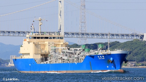
Kakuyu Maru
Current StatusWhere is the vessel?
Kakuyu Maru is currently in 14 nm N of Kobe, Kyota, based on AIS data received about 1h ago.
Latest AIS update:
Current position: 35.82551° N, 135.16817° E (14 nm N of Kobe, Kyota)
Average speed (last 7 days): Loading…
Average speed (last 30 days): Loading…
Vessel profile: Kakuyu Maru is a General Cargo Ship with dimensions 18m x 105m.
This page combines live AIS, route history, probable destination signals, nearby traffic, and port activity for practical vessel monitoring.
The current position of vessel Kakuyu Maru is 35.82551 lat / 135.16817 lng. Updated: 2026-05-15 07:26:33 UTCNearest reference points:
- 15 nm NW of SHIMONOHAMA
- Near Nada-Ku, Hyogo
- Near Kobe
Details:
Live Vessel Kakuyu Maru Analytics (details, animations, etc.)
Recent AIS points (UTC):
2026-05-15 05:00:23 UTC · 35.79695, 134.54254 · SOG 12.3 kn · COG 87°2026-05-15 05:10:04 UTC · 35.79788, 134.58308 · SOG 12.4 kn · COG 87°
2026-05-15 06:38:43 UTC · 35.81228, 134.96477 · SOG 12.8 kn · COG 88°
2026-05-15 07:26:33 UTC · 35.82551, 135.16817 · SOG 12 kn · COG 80°