 vesseltracker.com
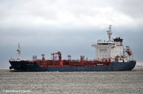
 Murray Star
Current Status
Where is the vessel?
Murray Star is currently in Near TUZLA, based on AIS data received less than 1h ago.
Latest AIS update:
Current position: 40.83620° N, 29.27440° E (Near TUZLA)
Average speed (last 7 days): Loading…
Average speed (last 30 days): Loading…
Vessel profile: Murray Star is a Chemical Oil Products Tanker with dimensions 128m x 20m.
This page combines live AIS, route history, probable destination signals, nearby traffic, and port activity for practical vessel monitoring.
The current position of vessel Murray Star is 40.8362 lat / 29.2744 lng. Updated: 2026-05-01 22:20:05 UTCNearest reference points:
- Near TUZLA
- Near PENDIK
- Near Tuzla Free Zone
Currently sailing under the flag of Malta ![]()
Murray Star built in 2011 year
Deadweight:
13019 tDetails:
Live Vessel Murray Star Analytics (details, animations, etc.)
Recent AIS points (UTC):
2026-05-01 19:08:04 UTC · 40.83630, 29.27420 · SOG 0 kn · COG 239°2026-05-01 19:59:06 UTC · 40.83630, 29.27430 · SOG 0 kn · COG 239°
2026-05-01 22:02:00 UTC · 40.83630, 29.27440 · SOG 0 kn · COG 239°
2026-05-01 22:20:05 UTC · 40.83620, 29.27440 · SOG 0 kn · COG 239°