 vesseltracker.com
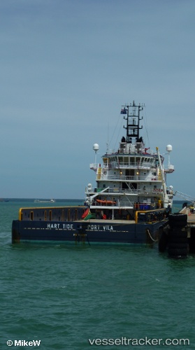
 HART TIDE
Current Status
Where is the vessel?
HART TIDE is currently in 52 nm SE of Santan Terminal, based on AIS data received less than 1h ago.
Latest AIS update:
Current position: 0.58225° S, 118.24349° E (52 nm SE of Santan Terminal)
Average speed (last 7 days): Loading…
Average speed (last 30 days): Loading…
Vessel profile: HART TIDE is a Offshore Supply Ship with dimensions m x m.
This page combines live AIS, route history, probable destination signals, nearby traffic, and port activity for practical vessel monitoring.
The current position of vessel HART TIDE is -0.58225 lat / 118.24349 lng. Updated: 2026-05-14 04:49:21 UTCNearest reference points:
- 56 nm SE of Santan Terminal
- 16 nm SE of Santan Terminal
- 24 nm E of Handil
Currently sailing under the flag of Indonesia ![]()
Details:
Live Vessel HART TIDE Analytics (details, animations, etc.)
Recent AIS points (UTC):
2026-05-14 01:07:20 UTC · -0.58713, 118.24013 · SOG 0 kn · COG 194°2026-05-14 01:37:21 UTC · -0.58714, 118.24012 · SOG 0 kn · COG 195°
2026-05-14 03:47:30 UTC · -0.58211, 118.24353 · SOG 0.2 kn · COG 0°
2026-05-14 04:49:21 UTC · -0.58225, 118.24349 · SOG 0 kn · COG 359°