 vesseltracker.com
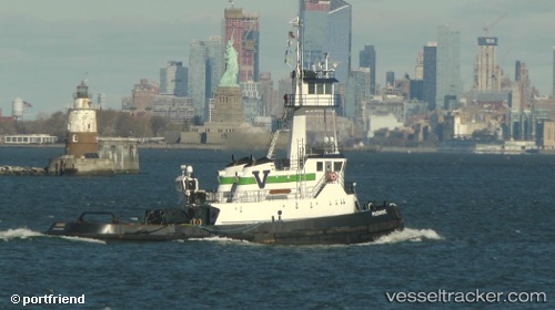
 Pocomoke
Current Status
Where is the vessel?
Pocomoke is currently in Near Locust Valley, based on AIS data received about 1h ago.
Latest AIS update:
Current position: 40.92476° N, 73.63679° W (Near Locust Valley)
Average speed (last 7 days): Loading…
Average speed (last 30 days): Loading…
Vessel profile: Pocomoke is a Pusher Tug with dimensions 30m x 11m.
This page combines live AIS, route history, probable destination signals, nearby traffic, and port activity for practical vessel monitoring.
The current position of vessel Pocomoke is 40.92476 lat / -73.63679 lng. Updated: 2026-05-14 14:14:14 UTCNearest reference points:
- Near Larchmont
- Near Purchase
- Near Bellmore
Currently sailing under the flag of USA ![]()
Pocomoke built in 2008 year
Deadweight:
194 tDetails:
Live Vessel Pocomoke Analytics (details, animations, etc.)
Recent AIS points (UTC):
2026-05-14 10:30:34 UTC · 40.64723, -74.04060 · SOG 7.7 kn · COG 78°2026-05-14 11:26:38 UTC · 40.74117, -73.96843 · SOG 7.7 kn · COG 353°
2026-05-14 13:39:54 UTC · 40.88630, -73.71396 · SOG 7.4 kn · COG 53°
2026-05-14 14:14:14 UTC · 40.92476, -73.63679 · SOG 7.5 kn · COG 62°