 vesseltracker.com
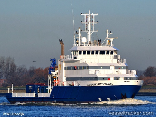
 Noordhoek Pathfinder
Current Status
Where is the vessel?
Noordhoek Pathfinder is currently in Near BEVERWIJK, based on AIS data received about 1h ago.
Latest AIS update:
Current position: 52.47537° N, 4.66301° E (Near BEVERWIJK)
Average speed (last 7 days): Loading…
Average speed (last 30 days): Loading…
Vessel profile: Noordhoek Pathfinder is a Offshore Support Vessel with dimensions 61m x 13m.
This page combines live AIS, route history, probable destination signals, nearby traffic, and port activity for practical vessel monitoring.
The current position of vessel Noordhoek Pathfinder is 52.47537 lat / 4.66301 lng. Updated: 2026-05-14 11:37:41 UTCNearest reference points:
- Near BEVERWIJK
- Near IJmuiden/Velsen
- Near Ijmuiden
Currently sailing under the flag of Netherlands ![]()
Noordhoek Pathfinder built in 2010 year
Deadweight:
1810 tDetails:
Live Vessel Noordhoek Pathfinder Analytics (details, animations, etc.)
Recent AIS points (UTC):
2026-05-14 08:25:20 UTC · 52.47541, 4.66286 · SOG 0.1 kn · COG 153°2026-05-14 10:13:50 UTC · 52.47537, 4.66298 · SOG 0.1 kn · COG 153°
2026-05-14 10:42:10 UTC · 52.47520, 4.66310 · SOG 0.1 kn · COG 153°
2026-05-14 11:37:41 UTC · 52.47537, 4.66301 · SOG 0.2 kn · COG 153°