 vesseltracker.com
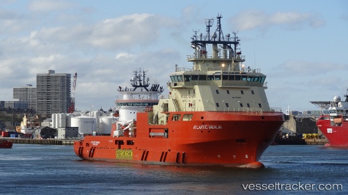
 ATLANTIC MERLIN
Current Status
Where is the vessel?
ATLANTIC MERLIN is currently in Near St. John’S, based on AIS data received less than 1h ago.
Latest AIS update:
Current position: 47.56788° N, 52.70096° W (Near St. John’S)
Average speed (last 7 days): Loading…
Average speed (last 30 days): Loading…
Vessel profile: ATLANTIC MERLIN is a Offshore Tug/Supply Ship with dimensions m x m.
This page combines live AIS, route history, probable destination signals, nearby traffic, and port activity for practical vessel monitoring.
The current position of vessel ATLANTIC MERLIN is 47.56788 lat / -52.70096 lng. Updated: 2026-05-14 01:25:51 UTCNearest reference points:
- Near St. John’S
- Near Witless Bay
- Near Catalina
Currently sailing under the flag of Canada ![]()
ATLANTIC MERLIN built in 2014 year
Deadweight:
4500 tDetails:
Live Vessel ATLANTIC MERLIN Analytics (details, animations, etc.)
Recent AIS points (UTC):
2026-05-13 22:46:46 UTC · 47.56788, -52.70096 · SOG 0 kn · COG 221°2026-05-14 00:25:50 UTC · 47.56787, -52.70096 · SOG 0.2 kn · COG 221°
2026-05-14 01:10:50 UTC · 47.56788, -52.70096 · SOG 0 kn · COG 221°
2026-05-14 01:25:51 UTC · 47.56788, -52.70096 · SOG 0.1 kn · COG 221°