 vesseltracker.com
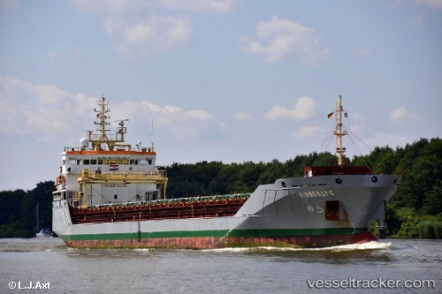
 KIMBERLY C
Current Status
Where is the vessel?
KIMBERLY C is currently in Near Oristano, based on AIS data received less than 1h ago.
Latest AIS update:
Current position: 39.86053° N, 8.47754° E (Near Oristano)
Average speed (last 7 days): Loading…
Average speed (last 30 days): Loading…
Vessel profile: KIMBERLY C is a General Cargo Ship with dimensions 106m x 15m.
This page combines live AIS, route history, probable destination signals, nearby traffic, and port activity for practical vessel monitoring.
The current position of vessel KIMBERLY C is 39.86053 lat / 8.47754 lng. Updated: 2026-05-14 17:21:51 UTCNearest reference points:
- Near CARLOFORTE
- Near Cagliari
- Near SARROCH
Currently sailing under the flag of Portugal (MAR) ![]()
KIMBERLY C built in 2011 year
Deadweight:
6806 tDetails:
Live Vessel KIMBERLY C Analytics (details, animations, etc.)
Recent AIS points (UTC):
2026-05-14 14:06:50 UTC · 39.86017, 8.47800 · SOG 0 kn · COG 236°2026-05-14 16:09:51 UTC · 39.86032, 8.47785 · SOG 0 kn · COG 228°
2026-05-14 16:18:51 UTC · 39.86035, 8.47780 · SOG 0 kn · COG 226°
2026-05-14 17:21:51 UTC · 39.86053, 8.47754 · SOG 0 kn · COG 212°