 vesseltracker.com
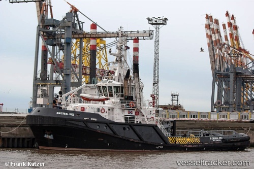
 IBAIZABAL DIEZ
Current Status
Where is the vessel?
IBAIZABAL DIEZ is currently in Near PUNTA LANGOSTEIRA, based on AIS data received less than 1h ago.
Latest AIS update:
Current position: 43.34650° N, 8.52991° W (Near PUNTA LANGOSTEIRA)
Average speed (last 7 days): Loading…
Average speed (last 30 days): Loading…
Vessel profile: IBAIZABAL DIEZ is a Tug with dimensions 37m x 14m.
This page combines live AIS, route history, probable destination signals, nearby traffic, and port activity for practical vessel monitoring.
The current position of vessel IBAIZABAL DIEZ is 43.34650 lat / -8.52991 lng. Updated: 2026-05-14 04:15:06 UTCNearest reference points:
- Near PUNTA LANGOSTEIRA
- Near La Coruna
- Near Ferrol
Currently sailing under the flag of Spain ![]()
IBAIZABAL DIEZ built in 2012 year
Deadweight:
519 tDetails:
Live Vessel IBAIZABAL DIEZ Analytics (details, animations, etc.)
Recent AIS points (UTC):
2026-05-14 01:37:15 UTC · 43.34647, -8.52988 · SOG 0.1 kn · COG 316°2026-05-14 01:52:07 UTC · 43.34647, -8.52992 · SOG 0.1 kn · COG 315°
2026-05-14 03:23:26 UTC · 43.34648, -8.52990 · SOG 0.1 kn · COG 315°
2026-05-14 04:15:06 UTC · 43.34650, -8.52991 · SOG 0 kn · COG 313°