 vesseltracker.com
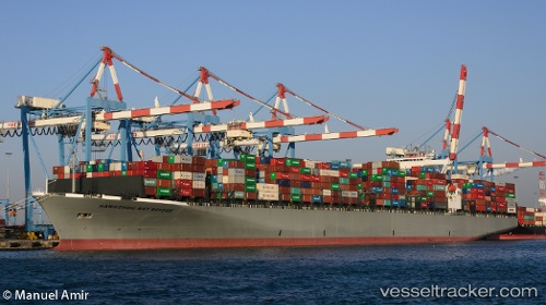
 ONE HANGZHOU BAY
Current Status
Where is the vessel?
ONE HANGZHOU BAY is currently in 327 nm S of Abakaliki, based on AIS data received about 2h ago.
Latest AIS update:
Current position: 0.90900° N, 85.56721° E (327 nm S of Abakaliki)
Average speed (last 7 days): Loading…
Average speed (last 30 days): Loading…
Vessel profile: ONE HANGZHOU BAY is a Container Ship with dimensions m x m.
This page combines live AIS, route history, probable destination signals, nearby traffic, and port activity for practical vessel monitoring.
The current position of vessel ONE HANGZHOU BAY is 0.90900 lat / 85.56721 lng. Updated: 2026-04-25 20:07:58 UTCNearest reference points:
- 331 nm S of Abakaliki
- Open sea, approx. 401 nm off the nearest listed port
- Open sea, approx. 470 nm off the nearest listed port
Currently sailing under the flag of Japan ![]()
Details:
Live Vessel ONE HANGZHOU BAY Analytics (details, animations, etc.)
Recent AIS points (UTC):
2026-04-25 17:34:17 UTC · 1.24814, 85.99208 · SOG 12.8 kn · COG 233°2026-04-25 18:17:27 UTC · 1.15346, 85.87163 · SOG 12.8 kn · COG 233°
2026-04-25 18:17:27 UTC · 1.15346, 85.87163 · SOG 12.8 kn · COG 233°
2026-04-25 20:07:58 UTC · 0.90900, 85.56721 · SOG 12.8 kn · COG 233°