 vesseltracker.com
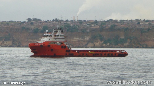
 HAI DUONG 68
Current Status
Where is the vessel?
HAI DUONG 68 is currently in 80 nm S of Latputta, based on AIS data received about 1h ago.
Latest AIS update:
Current position: 14.84667° N, 95.04500° E (80 nm S of Latputta)
Average speed (last 7 days): Loading…
Average speed (last 30 days): Loading…
Vessel profile: HAI DUONG 68 is a Offshore Supply Ship with dimensions 24m x 75m.
This page combines live AIS, route history, probable destination signals, nearby traffic, and port activity for practical vessel monitoring.
The current position of vessel HAI DUONG 68 is 14.84667 lat / 95.04500 lng. Updated: 2026-05-13 23:19:58 UTCNearest reference points:
- 84 nm NW of Yetagun Field
- Near Thilawa
- 80 nm SW of Sangkhla Buri Customs House
Currently sailing under the flag of Vietnam ![]()
HAI DUONG 68 built in 2012 year
Deadweight:
3284 tDetails:
Live Vessel HAI DUONG 68 Analytics (details, animations, etc.)
Recent AIS points (UTC):
2026-05-13 20:10:56 UTC · 15.08333, 94.84333 · SOG 5 kn · COG -1°2026-05-13 21:55:57 UTC · 14.95167, 94.95333 · SOG 5 kn · COG -1°
2026-05-13 22:43:58 UTC · 14.89167, 95.00333 · SOG 5 kn · COG -1°
2026-05-13 23:19:58 UTC · 14.84667, 95.04500 · SOG 6 kn · COG -1°