 vesseltracker.com
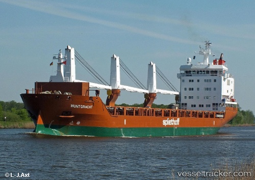
 Muntgracht
Current Status
Where is the vessel?
Muntgracht is currently in 51 nm N of Santa Cruz da Graciosa, based on AIS data received less than 1h ago.
Latest AIS update:
Current position: 39.93333° N, 27.98833° W (51 nm N of Santa Cruz da Graciosa)
Average speed (last 7 days): Loading…
Average speed (last 30 days): Loading…
Vessel profile: Muntgracht is a General Cargo Ship with dimensions 142m x 19m.
This page combines live AIS, route history, probable destination signals, nearby traffic, and port activity for practical vessel monitoring.
The current position of vessel Muntgracht is 39.93333 lat / -27.98833 lng. Updated: 2026-05-14 15:59:56 UTCNearest reference points:
- Near Praia Da Vitoria
- 81 nm SW of Matillas
Currently sailing under the flag of Netherlands ![]()
Muntgracht built in 2012 year
Deadweight:
11744 tDetails:
Live Vessel Muntgracht Analytics (details, animations, etc.)
Recent AIS points (UTC):
2026-05-14 13:26:54 UTC · 40.09667, -28.71500 · SOG 13 kn · COG -1°2026-05-14 13:47:56 UTC · 40.07333, -28.61500 · SOG 13 kn · COG -1°
2026-05-14 15:59:56 UTC · 39.93333, -27.98833 · SOG 13 kn · COG -1°
2026-05-14 15:59:56 UTC · 39.93333, -27.98833 · SOG 13 kn · COG -1°