 vesseltracker.com
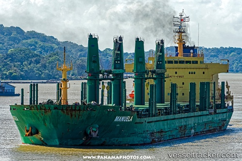
Manuela
Current StatusWhere is the vessel?
Manuela is currently in 14 nm N of Macinaggio, based on AIS data received about 1h ago.
Latest AIS update:
Current position: 43.17596° N, 9.51192° E (14 nm N of Macinaggio)
Average speed (last 7 days): Loading…
Average speed (last 30 days): Loading…
Vessel profile: Manuela is a Bulk Carrier with dimensions 28m x 180m.
This page combines live AIS, route history, probable destination signals, nearby traffic, and port activity for practical vessel monitoring.
The current position of vessel Manuela is 43.17596 lat / 9.51192 lng. Updated: 2026-05-15 01:17:20 UTCNearest reference points:
- 12 nm N of Macinaggio
- 12 nm NE of Bastia
- Near Lucciana
Details:
Live Vessel Manuela Analytics (details, animations, etc.)
Recent AIS points (UTC):
2026-05-14 22:00:41 UTC · 42.82371, 8.71681 · SOG 12.6 kn · COG 54°2026-05-14 22:35:31 UTC · 42.89307, 8.85369 · SOG 12.6 kn · COG 54°
2026-05-14 23:58:01 UTC · 43.05703, 9.16631 · SOG 12.3 kn · COG 52°
2026-05-15 01:17:20 UTC · 43.17596, 9.51192 · SOG 12.7 kn · COG 79°