 vesseltracker.com
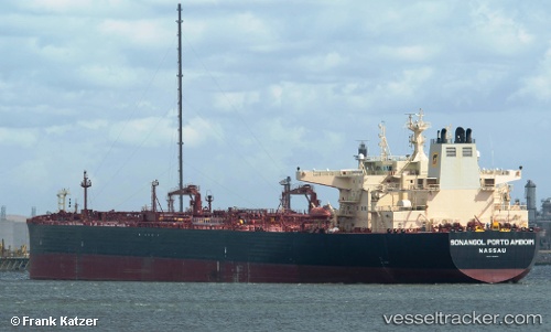
 Sonangol Portoamboi
Current Status
Where is the vessel?
Sonangol Portoamboi is currently in Near Oakland, based on AIS data received about 1h ago.
Latest AIS update:
Current position: 37.71730° N, 122.33030° W (Near Oakland)
Average speed (last 7 days): Loading…
Average speed (last 30 days): Loading…
Vessel profile: Sonangol Portoamboi is a Crude Oil Tanker with dimensions 274m x 48m.
This page combines live AIS, route history, probable destination signals, nearby traffic, and port activity for practical vessel monitoring.
The current position of vessel Sonangol Portoamboi is 37.71730 lat / -122.33030 lng. Updated: 2026-04-07 23:46:10 UTCNearest reference points:
- Near Oakland
- Near Treasure Island/Los Angeles
- Near San Francisco
Currently sailing under the flag of Bahamas ![]()
Sonangol Portoamboi built in 2012 year
Deadweight:
157639 tDetails:
Live Vessel Sonangol Portoamboi Analytics (details, animations, etc.)
Recent AIS points (UTC):
2026-04-07 17:25:10 UTC · 37.72082, -122.33233 · SOG 0.1 kn · COG 210°2026-04-07 20:04:10 UTC · 37.71733, -122.33058 · SOG 0 kn · COG 312°
2026-04-07 22:10:10 UTC · 37.71702, -122.33084 · SOG 0 kn · COG 312°
2026-04-07 23:46:10 UTC · 37.71730, -122.33030 · SOG 0 kn · COG 302°