 vesseltracker.com
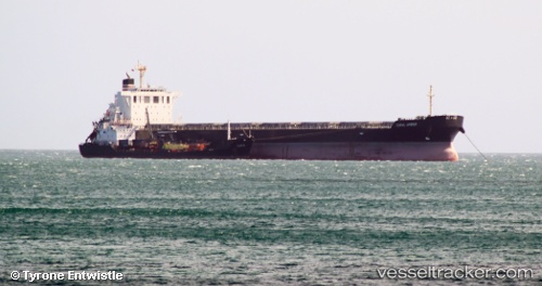
 STARDUST
Current Status
Where is the vessel?
STARDUST is currently in 180 nm NW of Villagonzalo Pedernales, based on AIS data received less than 1h ago.
Latest AIS update:
Current position: 43.95276° N, 38.09206° W (180 nm NW of Villagonzalo Pedernales)
Average speed (last 7 days): Loading…
Average speed (last 30 days): Loading…
Vessel profile: STARDUST is a Bulk Carrier with dimensions 32m x 221m.
This page combines live AIS, route history, probable destination signals, nearby traffic, and port activity for practical vessel monitoring.
The current position of vessel STARDUST is 43.95276 lat / -38.09206 lng. Updated: 2026-05-01 01:55:49 UTCCurrently sailing under the flag of Liberia ![]()
STARDUST built in 2012 year
Deadweight:
78072 tDetails:
Live Vessel STARDUST Analytics (details, animations, etc.)
Recent AIS points (UTC):
2026-04-30 22:19:01 UTC · 44.13627, -37.16459 · SOG 12.3 kn · COG 259°2026-05-01 00:11:48 UTC · 44.04448, -37.64713 · SOG 11.4 kn · COG 251°
2026-05-01 01:03:09 UTC · 44.00070, -37.86599 · SOG 11.9 kn · COG 251°
2026-05-01 01:55:49 UTC · 43.95276, -38.09206 · SOG 11.9 kn · COG 256°