 vesseltracker.com
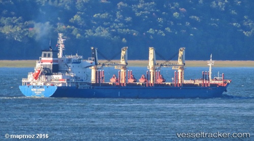
 Nestor I
Current Status
Where is the vessel?
Nestor I is currently in 35 nm W of Vikati Sadam, based on AIS data received less than 1h ago.
Latest AIS update:
Current position: 58.58291° N, 20.81954° E (35 nm W of Vikati Sadam)
Average speed (last 7 days): Loading…
Average speed (last 30 days): Loading…
Vessel profile: Nestor I is a Bulk Carrier with dimensions 180m x 28m.
This page combines live AIS, route history, probable destination signals, nearby traffic, and port activity for practical vessel monitoring.
The current position of vessel Nestor I is 58.58291 lat / 20.81954 lng. Updated: 2026-05-14 21:37:56 UTCNearest reference points:
- 37 nm W of Vikati Sadam
- 20 nm W of Kalana
- 18 nm N of Ventspils
Currently sailing under the flag of Liberia ![]()
Nestor I built in 2011 year
Deadweight:
32312 tDetails:
Live Vessel Nestor I Analytics (details, animations, etc.)
Recent AIS points (UTC):
2026-05-14 18:24:25 UTC · 59.11973, 21.58974 · SOG 12.5 kn · COG 220°2026-05-14 19:41:55 UTC · 58.90163, 21.27483 · SOG 12.7 kn · COG 216°
2026-05-14 19:50:35 UTC · 58.87689, 21.23999 · SOG 12.6 kn · COG 215°
2026-05-14 21:37:56 UTC · 58.58291, 20.81954 · SOG 12.2 kn · COG 217°