 vesseltracker.com
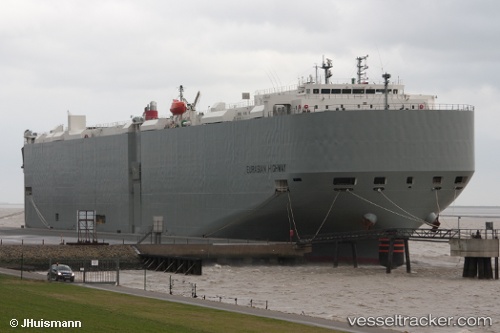
 Eurasian Highway
Current Status
Where is the vessel?
Eurasian Highway is currently in 36 nm SE of Shima, Mie, based on AIS data received about 1h ago.
Latest AIS update:
Current position: 33.90873° N, 137.34431° E (36 nm SE of Shima, Mie)
Average speed (last 7 days): Loading…
Average speed (last 30 days): Loading…
Vessel profile: Eurasian Highway is a Vehicles Carrier with dimensions 199m x 32m.
This page combines live AIS, route history, probable destination signals, nearby traffic, and port activity for practical vessel monitoring.
The current position of vessel Eurasian Highway is 33.90873 lat / 137.34431 lng. Updated: 2026-05-14 07:45:53 UTCNearest reference points:
- 20 nm S of HAMAJIMA
- 17 nm S of TOYOHASHI
- 12 nm E of TOBA
Currently sailing under the flag of Japan ![]()
Eurasian Highway built in 2012 year
Deadweight:
18709 tDetails:
Live Vessel Eurasian Highway Analytics (details, animations, etc.)
Recent AIS points (UTC):
2026-05-14 04:27:43 UTC · 33.89681, 137.46124 · SOG 1.8 kn · COG 209°2026-05-14 06:28:33 UTC · 33.90089, 137.38625 · SOG 1.8 kn · COG 227°
2026-05-14 07:36:12 UTC · 33.90686, 137.34891 · SOG 1.6 kn · COG 219°
2026-05-14 07:45:53 UTC · 33.90873, 137.34431 · SOG 1.5 kn · COG 223°