 vesseltracker.com
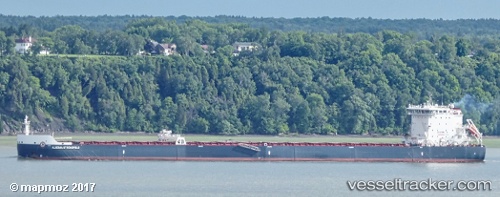
 Algoma Strongfield
Current Status
Where is the vessel?
Algoma Strongfield is currently in Near Virgil, based on AIS data received less than 1h ago.
Latest AIS update:
Current position: 43.12021° N, 79.19451° W (Near Virgil)
Average speed (last 7 days): Loading…
Average speed (last 30 days): Loading…
Vessel profile: Algoma Strongfield is a Self Discharging Bulk Carrier with dimensions 226m x 24m.
This page combines live AIS, route history, probable destination signals, nearby traffic, and port activity for practical vessel monitoring.
The current position of vessel Algoma Strongfield is 43.12021 lat / -79.19451 lng. Updated: 2026-05-14 14:14:32 UTCNearest reference points:
- Near TORONTO
- Near OAKVILLE
- Near Hannon
Currently sailing under the flag of Canada ![]()
Details:
Live Vessel Algoma Strongfield Analytics (details, animations, etc.)
Recent AIS points (UTC):
2026-05-14 10:30:33 UTC · 42.89758, -79.24628 · SOG 0.3 kn · COG 9°2026-05-14 11:26:33 UTC · 42.95004, -79.23182 · SOG 7.7 kn · COG 15°
2026-05-14 13:39:52 UTC · 43.11468, -79.19538 · SOG 0 kn · COG 7°
2026-05-14 14:14:32 UTC · 43.12021, -79.19451 · SOG 0.8 kn · COG 10°