 vesseltracker.com
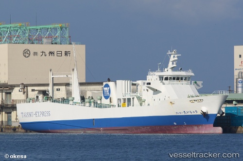
 Ferry Taisyu
Current Status
Where is the vessel?
Ferry Taisyu is currently in Near Hakata, based on AIS data received less than 1h ago.
Latest AIS update:
Current position: 33.60573° N, 130.38567° E (Near Hakata)
Average speed (last 7 days): Loading…
Average speed (last 30 days): Loading…
Vessel profile: Ferry Taisyu is a Ro Ro Cargo Ship with dimensions 90m x 14m.
This page combines live AIS, route history, probable destination signals, nearby traffic, and port activity for practical vessel monitoring.
The current position of vessel Ferry Taisyu is 33.60573 lat / 130.38567 lng. Updated: 2026-05-14 12:00:35 UTCNearest reference points:
- Near Hakata
- Near Hibiki-Nada
- Near KITAKYUSHU
Currently sailing under the flag of Japan ![]()
Details:
Live Vessel Ferry Taisyu Analytics (details, animations, etc.)
Recent AIS points (UTC):
2026-05-14 07:53:06 UTC · 33.60576, 130.38567 · SOG 0 kn · COG 152°2026-05-14 10:27:35 UTC · 33.60576, 130.38570 · SOG 0.1 kn · COG 152°
2026-05-14 11:02:57 UTC · 33.60564, 130.38560 · SOG 0 kn · COG 152°
2026-05-14 12:00:35 UTC · 33.60573, 130.38567 · SOG 0 kn · COG 152°