 vesseltracker.com
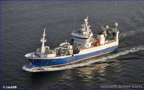
 Liafjord
Current Status
Where is the vessel?
Liafjord is currently in Near Torangsvåg, based on AIS data received less than 1h ago.
Latest AIS update:
Current position: 60.11471° N, 5.17173° E (Near Torangsvåg)
Average speed (last 7 days): Loading…
Average speed (last 30 days): Loading…
Vessel profile: Liafjord is a Fish Carrier with dimensions 64m x 64m.
This page combines live AIS, route history, probable destination signals, nearby traffic, and port activity for practical vessel monitoring.
The current position of vessel Liafjord is 60.11471 lat / 5.17173 lng. Updated: 2026-05-13 17:28:14 UTCNearest reference points:
- Near TORANGSVAG
- Near Glesvær
- Near SANDVIKVAAG
Currently sailing under the flag of Norway ![]()
Liafjord built in 2012 year
Deadweight:
600 tDetails:
Live Vessel Liafjord Analytics (details, animations, etc.)
Recent AIS points (UTC):
2026-05-13 14:24:25 UTC · 60.11472, 5.17174 · SOG 0 kn · COG 121°2026-05-13 15:39:14 UTC · 60.11469, 5.17172 · SOG 0 kn · COG 122°
2026-05-13 16:35:34 UTC · 60.11470, 5.17171 · SOG 0 kn · COG 121°
2026-05-13 17:28:14 UTC · 60.11471, 5.17173 · SOG 0 kn · COG 122°