 vesseltracker.com
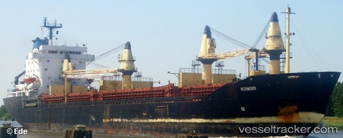
 MERCURIUS
Current Status
Where is the vessel?
MERCURIUS is currently in 17 nm N of Malia, based on AIS data received less than 1h ago.
Latest AIS update:
Current position: 35.54336° N, 25.59853° E (17 nm N of Malia)
Average speed (last 7 days): Loading…
Average speed (last 30 days): Loading…
Vessel profile: MERCURIUS is a Cargo with dimensions m x m.
This page combines live AIS, route history, probable destination signals, nearby traffic, and port activity for practical vessel monitoring.
The current position of vessel MERCURIUS is 35.54336 lat / 25.59853 lng. Updated: 2026-05-15 00:00:33 UTCNearest reference points:
- Near Iraklion
- Near Kali Limenes
- 20 nm S of Astypálaia
Currently sailing under the flag of Saint Kitts and Nevis ![]()
Details:
Live Vessel MERCURIUS Analytics (details, animations, etc.)
Recent AIS points (UTC):
2026-05-14 19:49:02 UTC · 35.45233, 26.16367 · SOG 7.3 kn · COG 288°2026-05-14 21:35:43 UTC · 35.50395, 25.91857 · SOG 6.7 kn · COG 288°
2026-05-14 22:43:03 UTC · 35.52342, 25.76355 · SOG 6.3 kn · COG 279°
2026-05-15 00:00:33 UTC · 35.54336, 25.59853 · SOG 6.5 kn · COG 275°