 vesseltracker.com
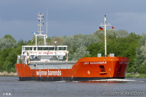
 Lady Alexandra
Current Status
Where is the vessel?
Lady Alexandra is currently in 65 nm S of Mirabel, based on AIS data received about 1h ago.
Latest AIS update:
Current position: 38.76667° N, 6.25833° E (65 nm S of Mirabel)
Average speed (last 7 days): Loading…
Average speed (last 30 days): Loading…
Vessel profile: Lady Alexandra is a General Cargo Ship with dimensions 88m x 88m.
This page combines live AIS, route history, probable destination signals, nearby traffic, and port activity for practical vessel monitoring.
The current position of vessel Lady Alexandra is 38.76667 lat / 6.25833 lng. Updated: 2026-04-12 23:27:56 UTCNearest reference points:
- Near Carmona
- 42 nm NW of Mirabel
- 42 nm NE of Mirabel
Currently sailing under the flag of Netherlands ![]()
Lady Alexandra built in 2012 year
Deadweight:
3700 tDetails:
Live Vessel Lady Alexandra Analytics (details, animations, etc.)
Recent AIS points (UTC):
2026-04-12 17:42:53 UTC · 38.80500, 5.20333 · SOG 9 kn · COG -1°2026-04-12 19:48:55 UTC · 38.77667, 5.60667 · SOG 8 kn · COG -1°
2026-04-12 21:21:53 UTC · 38.77667, 5.88667 · SOG 8 kn · COG -1°
2026-04-12 23:27:56 UTC · 38.76667, 6.25833 · SOG 8 kn · COG -1°