 vesseltracker.com
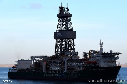
 Ocean Rig Skyros
Current Status
Where is the vessel?
Ocean Rig Skyros is currently in 21 nm E of Salceda, based on AIS data received less than 1h ago.
Latest AIS update:
Current position: 4.64299° N, 4.10603° W (21 nm E of Salceda)
Average speed (last 7 days): Loading…
Average speed (last 30 days): Loading…
Vessel profile: Ocean Rig Skyros is a Drilling Ship with dimensions 227m x 42m.
This page combines live AIS, route history, probable destination signals, nearby traffic, and port activity for practical vessel monitoring.
The current position of vessel Ocean Rig Skyros is 4.64299 lat / -4.10603 lng. Updated: 2026-05-14 19:48:20 UTCNearest reference points:
- Near Espoir
- Near Vridi
- Near Abidjan
Currently sailing under the flag of Marshall Is ![]()
Ocean Rig Skyros built in 2013 year
Deadweight:
60130 tDetails:
Live Vessel Ocean Rig Skyros Analytics (details, animations, etc.)
Recent AIS points (UTC):
2026-05-14 16:32:08 UTC · 4.64299, -4.10604 · SOG 0.3 kn · COG 235°2026-05-14 18:09:00 UTC · 4.64297, -4.10603 · SOG 0.2 kn · COG 235°
2026-05-14 19:08:00 UTC · 4.64298, -4.10605 · SOG 0 kn · COG 235°
2026-05-14 19:48:20 UTC · 4.64299, -4.10603 · SOG 0.4 kn · COG 235°