 vesseltracker.com
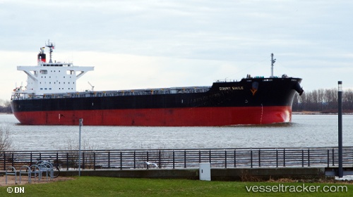
Sunny Smile
Current StatusWhere is the vessel?
Sunny Smile is currently in Near Boyne Island, based on AIS data received less than 1h ago.
Latest AIS update:
Current position: 23.84917° S, 151.47691° E (Near Boyne Island)
Average speed (last 7 days): Loading…
Average speed (last 30 days): Loading…
Vessel profile: Sunny Smile is a Bulk Carrier with dimensions 38m x 235m.
This page combines live AIS, route history, probable destination signals, nearby traffic, and port activity for practical vessel monitoring.
The current position of vessel Sunny Smile is -23.84917 lat / 151.47691 lng. Updated: 2026-05-14 04:07:06 UTCNearest reference points:
- Near Boyne Island
- Near Gladstone Harbor
- Near ROSSLYN
Details:
Live Vessel Sunny Smile Analytics (details, animations, etc.)
Recent AIS points (UTC):
2026-05-13 23:28:07 UTC · -23.84813, 151.47786 · SOG 0 kn · COG 154°2026-05-14 01:31:07 UTC · -23.84877, 151.47714 · SOG 0 kn · COG 126°
2026-05-14 01:52:07 UTC · -23.84897, 151.47704 · SOG 0 kn · COG 117°
2026-05-14 04:07:06 UTC · -23.84917, 151.47691 · SOG 0.1 kn · COG 108°